Abstract
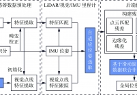
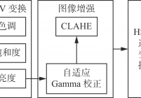
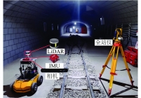
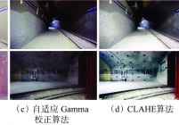
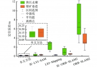
Mobile robots based on simultaneous localization and mapping (SLAM) technology can quickly, accurately, and automatically collect spatial data for spatial intelligent perception and environmental map construction. It is the key to achieving intelligent and unmanned coal mines. However, the current multi sensor fusion SLAM method in coal mines suffers from degradation and failure in robot front-end pose estimation, as well as insufficient precision in back-end fusion. This study proposes a LiDAR-visual-IMU adaptive fusion SLAM method for underground mobile robots in coal mines. The method clusters and segments LiDAR point cloud data, extracts line and surface features, and uses IMU pre integration state for distortion correction. The method uses image enhancement algorithm based on adaptive Gamma correction and contrast limited adaptive histogram equalization (CLAHE) to process low light images, and then extracts visual point and line features. The method provides initial pose values for LiDAR feature matching and visual feature tracking using IMU pre integration state. The pose of the mobile robot is obtained by matching the line and surface features of adjacent frames of LiDAR. Then, visual point and line feature tracking is performed to calculate the LiDAR, visual, and IMU pose changes. The stability of the front-end odometer is detected by setting dynamic thresholds, and the optimal pose is adaptively selected. The method constructs residuals for different sensors, including point cloud matching residuals, IMU pre integration residuals, visual point line residuals, and edge residuals. In order to balance precision and real-time performance, a sliding window based joint nonlinear optimization of multi-source data for laser point cloud features, visual features, and IMU measurements is implemented to achieve continuous and reliable SLAM in coal mines. Experimental verification is conducted on the effects before and after image enhancement. The results show that the image enhancement algorithm based on adaptive Gamma correction and CLAHE can significantly improve the brightness and contrast of the backlight and lighting areas, increase the feature information in the image, and significantly improve the quality of feature point extraction and matching. It achieves a matching success rate of 90.7%. To verify the performance of the proposed method, experimental verification is conducted in narrow corridor and coal mine roadway scenarios. The results show that the root mean square error of the proposed method in narrow corridor scenarios is 0.15 m, and the consistency of the constructed point cloud map is high. The root mean square error of positioning in the coal mine roadway scenario is 0.19 m. The constructed point cloud map can truly reflect the underground environment of the coal mine.


 工矿自动化
工矿自动化  2024年第05期