-
全部


主办单位:煤炭科学研究总院有限公司、中国煤炭学会学术期刊工作委员会
Aquifer water abundance evaluation based on distance function
胡东祥田波吕祥海吕文茂任昱颖
HU Dongxiang;TIAN Bo;LYU Xianghai;LYU Wenmao;REN Yuying
兖矿能源集团股份有限公司 地质与测量部山东能源集团有限公司
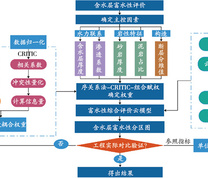
为了合理有效地评价厚松散层下组含水层富水性,提出基于距离函数组合赋权—云模型的含水层富水性评价方法。以兖州矿区兴隆庄煤矿为研究对象,选取含水层厚度、渗透系数、砂岩厚度、泥岩占比和断层分维值作为富水性评价指标,其中断层分维值指标依据分形理论分析与量化,采用序关系分析法和CRITIC法,并结合基于距离函数组合赋权模型确定各指标权重,将云模型引入富水性评价,建立基于云模型的含水层富水性评价方法,并应用ArcGIS分析研究区含水层富水性。结果表明:研究区富水性呈现中部强、西北与西南弱的特点,受断层构造影响较大,与基于研究区钻孔单位涌水量推断的富水性分级结果一致,说明建立的富水性评价模型具有可靠性。
In order to reasonably and effectively evaluate the water richness of aquifers under thick loose layer, an evaluation method of water richness of aquifers based on distance function combination-weighted cloud model was proposed. In this study, taking Xinglongzhuang Coal Mine in Yanzhou mining area as the research object, aquifer thickness, permeability coefficient, sandstone thickness, mudstone proportion and fault fractal dimension were selected as the water-rich evaluation indexes. The fault fractal dimension indexes were analyzed and quantified according to fractal theory. The sequence relation analysis method and CRITIC method were adopted. The weight of each index was determined by a combinated weighting model based on distance function. The aquifer richness evaluation method based on cloud model was established. ArcGIS was applied to analyze the water abundence of the aquifer in the study area. The results showed that the water abundance of the study area was strong in the middle, but weak in the northwest and southwest, and was greatly affected by fault structure. The results were consistent with the water abundance classification. These were based on the unit water inflow of boreholes in the study area, and thereby indicating the reliability of the established water abundance evaluation model.
富水性评价分形理论序关系分析法CRITIC距离函数云模型
water abundance evaluation;fractal theory;order relation analysis method;CRITIC;distance function;cloud model
图(5) / 表(4)


主办单位:煤炭科学研究总院有限公司 中国煤炭学会学术期刊工作委员会
 矿业安全与环保
  2024年第06期