-
全部


主办单位:煤炭科学研究总院有限公司、中国煤炭学会学术期刊工作委员会
 12
12
 0
0
Jing LiJörg BenndorfPaweł Trybała
Faculty of Geosciences, Geoengineering and Mining, Institute of Mine Surveying and Geodesy, TU Bergakademie FreibergFaculty of Geoengineering, Mining and Geology, Wrocław University of Science and Technology3D Optical Metrology Unit, Bruno Kessler Foundation
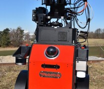
Geo-monitoring provides quantitative and reliable information to identify hazards and adopt appropriate measures timely. However, this task inherently exposes monitoring staff to hazardous environments, especially in underground settings. Since 2000s, robots have been widely applied in various fields and many studies have focused on establishing autonomous mobile robotic systems as well as solving the issue of underground navigation and mapping. However, only a few studies have conducted quantitative evaluations of these methods, and almost none have provided a systematic and comprehensive assessment of the suitability of mapping robots for underground geo-monitoring. In this study, a methodology for objective and quantitative assessment of the applicability of SLAM methods in underground geo-monitoring is proposed. This involves the development of an underground test field and some specific metrics, which allow detailed local accuracy analysis of point measurements, line segments, and areas using artificial targets. With this proposed methodology, a series of repeated experimental measurements has been performed with an autonomous driving robot and the selected LiDAR- and visual-based SLAM methods. The resulting point cloud was compared with the reference data measured by a total station and a terrestrial laser scanner. The accuracy and precision of the selected SLAM methods as well as the verifiability and reliability of the results are evaluated and discussed by analysing quantities such as the deviations of the control points coordinates, cloud-to-cloud distances between the test and reference point cloud, normal vector, centre point coordinates and area of the planar objects. The results demonstrate that the HDL Graph SLAM achieves satisfactory precision, accuracy, and repeatability with a mean cloud-to-cloud distance of 0.12 m (with a standard deviation of 0.13 m) in an 80 m closed-loop measurement area. Although RTAB-Map exhibits better plane-capturing capabilities, the measurement results reveal instability and inaccuracies.
Underground geo-monitoringMobile robotSimultaneous localization and mappingHDL Graph SLAMRTAB-Map
图(16) / 表(7)


主办单位:煤炭科学研究总院有限公司 中国煤炭学会学术期刊工作委员会
 国际煤炭科学技术学报(英文)
  2025年第01期


