
主办单位:煤炭科学研究总院有限公司、中国煤炭学会学术期刊工作委员会
Spatial-temporal heterogeneity of landscape ecological risk in Yushenfu Mining Area from 1995 to 2021
DU Huadong;LIU Yunlong;BI Yinli;SUN Hao;NING Benyan
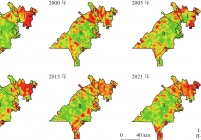
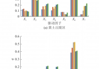
煤炭开采作为一种强烈的人类活动影响了矿区生态系统服务功能和经济价值,而相同气候环境不同地貌长时序空间尺度上矿区开发后景观生态风险演化特征对比研究较欠缺。以半干旱榆神府矿区为研究对象,基于1995—2021年Landsat数据,通过构建景观生态风险指数以及空间统计学分析,探究了近30年来矿区黄土丘陵和覆沙地两种不同地貌类型景观生态风险时空演化特征。结果表明:①1995—2000年间榆神府矿区两种地貌生态风险格局整体无明显变化;2000—2010年间黄土丘陵区景观低生态风险区向更高等级生态风险转变,2010年黄土丘陵区中高、中和中低生态风险区占比为70%,而覆沙区高生态风险区域虽增加但不显著,仍以中低生态风险区为主,占比为31%;2010—2021年矿区景观生态格局向着均匀化的方向发展,黄土丘陵区逐渐稳定为以中低、中和中高生态风险等级为主,2021年3个风险等级占比为74%,覆沙区也形成了以低、中低和中生态风险等级为主的分布情况,3个风险等级占比为77%,生态风险等级逐渐趋于稳定,生态风险格局不断优化;②1995—2021年榆神府矿区景观生态风险在空间上有明显的集聚分布特征,局部生态风险具有明显的热点、冷点区域,生态风险热点主要分布于煤炭开发时间长、地质环境损害较严重的东北部和东南部黄土丘陵区,生态风险冷点主要位于目前仍处于资源勘探普查的中部覆沙区;③人为干扰度是对榆神府矿区景观生态风险影响最大的驱动因子,黄土区与覆沙区决定力
As a strong human disturbance, coal mining has affected the ecosystem service function and economic value on mining area. However, there is a lack on the comparing for the long-term spatial scale evolution of landscape ecological risk after mining development based on different landforms in the same climate environment. Therefore, the spatial and temporal evolution characteristics of landscape ecological risk were explored on loess hilly and sandy land in the Yushenfu Mining Area based on the Landsat data from 1995—2021 with the construction of landscape ecological risk index and spatial statistical analysis methods. The results showed that: ① There was no significant changing between loess hilly and sandy land for the ecological risk pattern from 1995 to 2000. From 2000 to 2010, the low level ecological risk area changed to a higher level in the loess hilly region. In 2010, the proportion of medium-high, medium and medium-low ecological risk areas was 70% in the loess hilly area, while the high ecological risk area in the sand-covered area increased but not significant, and it was still dominated by medium-low ecological risk and account for 31%. Since 2010, the landscape ecological pattern tended to homogenization, and the landscape ecological risk gradually stabilized to a low-medium, medium and high-medium on loess hilly area, and the proportion of these three risk levels was 74% in 2021. The sandy landscape also formed a low, medium and low-medium ecological risk, and the proportion of the three risk levels was 77%, and decreased and stabilized gradually. ② From 1995 to 2021, the landscape ecological risks showed obvious spatially clustered distribution characteristics, and presented a clear hotspots and coldspots in Yushenfu Mining Area. The ecological risk hotspots were mainly located in the loess hilly area in the northeast and southeast of the study area where coal has been developed for a long time and the geological environment has been seriously damaged, and the ecological risk coldspots were mainly located in the sand-covered areas in the central part of study area which are still under resource exploration and survey. ③ Human disturbance was the most important factor affecting the landscape ecological risk in Yushenfu Mining Area, the determining force of
Yushenfu Mining Area;ecological restoration;landscape ecological risk;spatial statistics;geodetector


主办单位:煤炭科学研究总院有限公司 中国煤炭学会学术期刊工作委员会
 煤炭科学技术
  2024年第06期