-
全部


主办单位:煤炭科学研究总院有限公司、中国煤炭学会学术期刊工作委员会
Simulation analysis system for mine water hazard inundation
赫瑞王文娟邢延团杨欣
HE Rui;WANG Wenjuan;XING Yantuan;YANG Xin
宁夏回族自治区自然资源信息中心西安灵软信息技术有限公司合肥工业大学 资源与环境工程学院
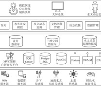
目前针对矿井巷道突发性水体流动模拟及应急疏散路径规划的研究存在巷道拓扑关系手动输入效率低、准确性差,淹没仿真多为定性模拟,缺乏对水流动态扩散过程的精确模拟等问题,提出一种矿井水害淹没仿真分析系统设计方案。生成巷道拓扑关系时采用巷道及节点数据自动创建无向图,进而处理隐式邻接关系,采用PostGIS函数计算弧段相交情况;淹没仿真采用暴雨洪水管理模型(SWMM)的动力波模拟法;应急疏散路径规划采用基于时变网络的Dijkstra算法,考虑巷道水深对通过速度的影响,Dijkstra算法分数据预处理、核心部分、后续处理3个阶段。以内蒙古神隆矿业有限公司为例,通过创建巷道拓扑关系、设定突水量等参数模拟突水事件,应用结果表明:矿井水害淹没仿真分析系统能准确呈现不同时间节点水流蔓延状况;规划的逃生路径能避开水位高、难行区域,通过时间符合实际。
Research on the simulation of sudden water flow in mine roadway and emergency evacuation path planning currently faces several challenges, including low efficiency and poor accuracy in manually inputting roadway topology relationships, qualitative inundation simulations, and a lack of precise simulation of the dynamic diffusion process of water flow. This study proposes a design scheme for a mine water hazard inundation simulation analysis system. During the generation of roadway topology relationships, an undirected graph was automatically created using roadway and node data, allowing the handling of implicit adjacency relationships. The intersection of arcs was calculated using PostGIS functions. For inundation simulation, the dynamic wave simulation method of the Storm Water Management Model (SWMM) was applied. Emergency evacuation path planning utilized Dijkstra's algorithm based on time-varying networks, considering the impact of water depth on escape speed. The Dijkstra algorithm was divided into three stages: data preprocessing, core computation, and post-processing. Taking Inner Mongolia Shenlong Mining Co., Ltd. as a case study, roadway topology relationships were created, and parameters such as flood volume were set to simulate sudden water influx events. The results demonstrated that the mine water hazard inundation simulation analysis system accurately reflected the spread of water flow at different time nodes. The planned evacuation paths successfully avoided areas with high water levels and difficult terrain, and the escape times were consistent with actual conditions.
矿井水害淹没仿真应急疏散路径暴雨洪水管理模型SWMM巷道拓扑关系动力波模拟法
mine water hazard inundation simulation;emergency evacuation path;Storm Water Management Model;SWMM;roadway topology relationships;dynamic wave simulation method
图(6) / 表(0)


主办单位:煤炭科学研究总院有限公司 中国煤炭学会学术期刊工作委员会
 工矿自动化
工矿自动化  2025年第01期